Geologic time vs. absolute time

Tomorrow I’ll post an interview with Dr. Randall Irmis, a geologist and paleobiologist working on the Colorado Plateau Coring Project. Today, I offer some background information on the geologic time scale and why it is so hard to figure out how old rocks are.
Earth’s history is divided into different chunks of geologic time, going all the way back to the formation of our planet. Unlike calendars or clocks, which divide time into units of equal length (e.g., days or seconds), the divisions of geologic time aren’t the same length. For example, the Mesozoic Era was ~186 million years long, whereas the preceding Paleozoic Era lasted ~289 million years. At 2.6 million years, the Pleistocene Epoch was much shorter than the Miocene Epoch (20.4 million years long). These divisions may seem arbitrary at first, but they’re not; geologic time is based on the succession of rock layers. Geologic time was the first method scientists used to understand the sequence of events in Earth’s history. More recently, we’ve used other methods to associate actual dates with different rock layers, thus linking geologic time (a relative method) with absolute time (= numbers of years old). This merger of geologic time and absolute time is the geologic time scale. (Don’t have a geologic time scale handy? Get one here for free!)
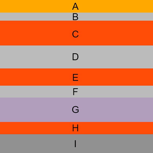
Geologic time is hard to sort out. The first step requires understanding the relative order of the rock layers. For almost 1000 years, we’ve recognized that rock layers are organized in the order in which they were deposited. This idea was first put forth by the Persian polymath Avicenna, and later presented more formally by the geologist and Catholic bishop Nicholas Steno. They proposed that within a vertical column of rock layers, the oldest ones are on the bottom, and the youngest are on top. Today, we call this the principle of superposition. Related to superposition is the principle of original horizontality, which just means that rock layers are more or less horizontal when they are first deposited. Horizontality is important because today’s rocks are not always in their original orientation.
Of course, the real world is more complicated than the above image. After rock layers form, their position can change through faulting or deformation. For example, the entire column can become tilted, in which case the rock layers get older or younger as you move horizontally along the ground, rather than vertically up a cliff:
There’s no place on Earth where rock layers going back to the beginning of the planet are visible all in one place, for several reasons. First, some of the layers are underground, so even if they’re present, we can’t always see them. Second, conditions aren’t always ideal for new rock formation, so there are times/places where new rock layers aren’t deposited. Also, rock layers erode at different rates in different places. For example, if there is a river running between two hills, the old rock layers will erode faster there than at the top of the hills. New rock layers are more likely to form in the riverbed and adjacent floodplains than on the hilltops. Different rates of erosion, deposition, and tectonic activity mean that the relative order of rock layers can be difficult to sort out in some places. To illustrate, look at the first image of rock layers above, with layers A through I. Let’s pretend that after layer A was deposited, a river carved out a valley:
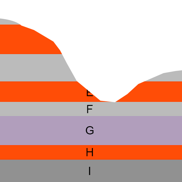 Depending on which mountain you’re on, you might not see layers B or C. Also, there is no trace of layer A in this whole region, although it may be preserved somewhere else. Now, let’s say that after some more time, sediments accumulate in the valley and new rock layers begin to form:
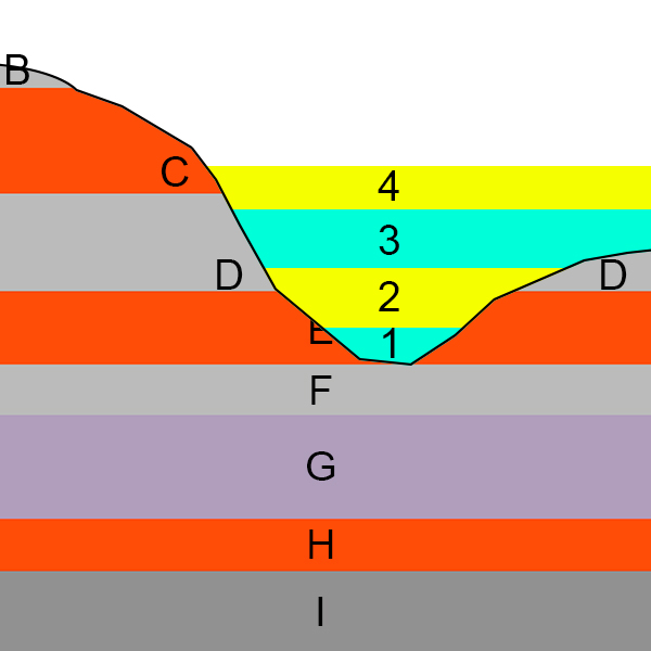 These processes occur over thousands or millions of years, so we can’t observe them in real time. But we can reconstruct the relative sequence of some events. For example, Layer 1 is older than layers 2, 3, and 4, which lie on top of it (thanks, superposition!). Layer 1 is younger than layer E (and F, G, H, and I), because it sits on top of E. Based on how layers 1-4 fill in the valley, we can also conclude that the erosion creating the valley likely happened after layer C was deposited. However, in order to figure out if layer 1 is younger than layer B, we would need to look at another mountain that preserved both B and 1 in the same vertical column.
Once you have the correct order of your rock layers sorted out, you can begin to associate the rock columns in your area with columns in other regions. If at least one rock layer stretches for miles and miles, it’s easy to confirm you’re dealing with the same layer. In the image below, you can just walk along the grey layer from point 1 to 2 to establish that it’s the same layer in both places. You might then hypothesize that the red layers are the same layer, based on their position relative to the grey layer.

More often than not, aligning rock columns is more complicated than this. Parts of your column might be underground, you might be missing rock layers from erosion, and/or the layers might vary regionally in thickness. Also, not all rocks deposited at the same point in time are identical. The appearance of rock layers depends on the local chemical and environmental conditions when they formed. Layers forming under the deep ocean will look very different than those forming in a coral reef, riverbed, desert, or swamp. Even more confusing, if environmental conditions are very similar, rocks deposited at two different points in time might look similar. So what’s a geologist to do?
One line of evidence for simultaneous deposition is when two layers contain the same fossil species. This is much easier to do for oceanic rock layers, because some ocean species (e.g., foraminifera, conodonts) are found around the globe. The types and sequence of these fossils can be helpful in lining up distant rock columns.
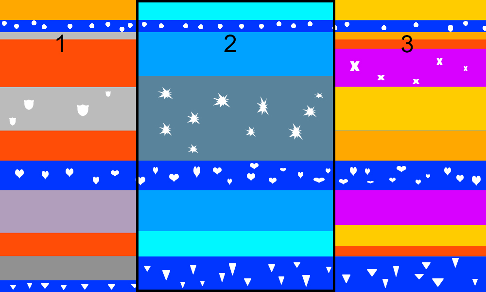 Let’s say columns 1, 2, and 3 are rock columns separated by thousands of miles. In this picture, fossils are white, blue layers were deposited underwater, and the other colors formed in terrestrial environments. Columns 1 and 3 are mostly terrestrial, but there are three times when the ocean invaded the land – times of high sea level or inland seas. Because the oceanic fossil species are identical, these are probably the same layers seen in column 2; if so, these layers represent the same points in time in all three columns. The sequence of the oceanic fossil species is important, too: triangles, then hearts, then circles in all three columns. It’s more evidence that we are dealing with the same overall sequence of events. If these are the same oceanic layers in columns 1 and 3, that means that the terrestrial layers between them are roughly correlated in time (I say “roughly” because there might be erosion or deposition gaps in one or both of the columns). Using the sequence of fossil species to correlate rock layers across big distances is called biostratigraphy, and it was extremely important for understanding the basic succession of rock layers on a global scale. Biostratigraphy is still important today for oil exploration, and is also used to align bores when drilling tunnels.
Once scientists had the rock layers aligned and their basic relative sequence sorted out, they noticed large-scale patterns in the succession of the fossils at a global scale. For example, individual species of ammonites were good for correlating very small chunks of the rock record. At the same relative point in the rock column, all ammonite species disappeared in rock formations all around the world. Globally, blastoids, trilobites, and acanthodians were common in oceanic rocks up until a certain point, after which those types of fossils were never found again. Above that point, totally different types of fossils were found, such as plesiosaurs. Similar patterns were found in oceanic fossils as in terrestrial animal and plant fossils. Because these major shifts in fossil faunas and floras occurred simultaneously all around the world, biostratigraphers recognized that they could be used to bracket and define major regions of the rock column. Smaller shifts (between species rather than faunas) could be used to bracket smaller subregions of the rock column.
This is still how geologic time divisions are defined; saying “Triassic Period” is just shorthand for “the time represented by the chunk of the global geologic column between when we first see the conodont species Hindeodus parvus, up until we start to see the ammonite Psiloceras spelae tirolicum and the foraminiferan Praegubkinella turgescens” (seriously).
You might be asking yourself, “Well, if the fossils define the geologic time periods, isn’t it circular to use geologic time to tell us how long ago those fossils lived?”
Good question, but no. Remember that geologic time only tells you relatively how old something is; it doesn’t give us an age in terms of number of years ago. Let’s use this analogy: my High School Era is defined as “the time between when I first started attending high school up until I graduated high school”. In the stratigraphic column of my life, the High School Era came after the Junior High Era, before the Undergraduate Era, and partially overlapped with the I Worked At A Movie Theater Epoch. If I find an essay I wrote for Mrs. Strutzel’s AP English class, I can tell you that it was written sometime during High School Era, and therefore before Undergraduate Era. But that doesn’t tell you how old I was in high school, or how many years ago that happened.
To find out how old something is in terms of years, you need a different metric, one that can determine absolute time. One common way to do this is radiometric dating. Radioactive isotopes are unstable. They break down (decay) over time, until they become stable isotopes (ones that don’t decay). Each radioactive isotope decays at a specific rate and results in specific stable isotopes – these are just basic properties of the atoms themselves. To estimate when that process started, you first take a substance and figure out its ratio between the radioactive isotopes and the stable (post-decay) isotopes. Then, you can use the rate of isotopic decay (also known as the half-life) to determine how many years of decay it took to result in that ratio – in other words, how many years since the process began, when the substance was 100% radioactive isotope and 0% stable isotope.
Carbon-14 is a radioactive isotope you’ve probably heard of. We use carbon dating to determine the ages of once-living things because it is present in plant and animal tissues. Carbon-14 decays pretty fast; a rate of 50% decay every 5,730 years. That rate of decay means Carbon-14 will completely convert to the stable isotopes Carbon-12 and Carbon-13 within ~60,000 years. This is a long time compared to the High School Era, but really short compared to the age of most rocks. So, we use other isotopes to date rocks; ones that decay at a slower rate. Common methods for dating rocks include uranium-lead dating and potassium-argon dating. These isotopes have much slower rates of decay (i.e., longer half-lives): the radioactive Uranium-235 converts to Lead-207 at a rate of 50% every 704 million years, and Potassium-40 converts to Argon-40 at a rate of 50% every 1.3 billion years.
Using radiometric dating methods, we can link absolute time to geologic time. These methods have already been used to date the rock layers containing the oceanic fossils that define and bracket the divisions of geologic time. So we now know how long each major division of geologic time lasted. Radiometric methods also have been used to date some terrestrial rock layers. Rather than roughly correlating terrestrial layers based on their associations with oceanic rock layers, we can now compare dates of terrestrial layers directly. As more and more rock layers are tagged with absolute dates, the geologic time scale is getting finer and finer resolution. As a result, we have a much better understanding the timing of events in Earth’s history and in Life’s history.
Tomorrow, I’ll talk more about a major new NSF-funded project that is extremely important both for aligning rock columns (calibrating geologic time) and putting absolute dates on individual rock layers (calibrating absolute time) from the Triassic Period.